XR-110
Spatial Computing and Area Scanning
XR-110 Extended Reality
Spring 2024
Overview
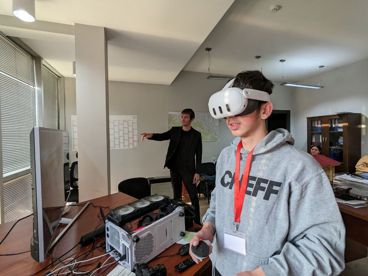
XR-110 is an introductory course on mixed and augmented reality technologies. Within this course, over the course of a month, we will implement a prototype application for virtual and augmented reality glasses (Oculus Quest 2 and 3).
As a referencewe take a project implemented in collaboration with the government of Mestia, which is a digital, interactive replica of real terrain (link 1,link 2)
The objectives of this course consist of several stages.
Initially introduce students to the basics of creating and working with XR technologies in three groups:
Dividing into groups is necessary in order to fit the entire course into a short period of time, not to make the groups too large (no more than 3-4 people) for your comfort, and also to give experience in the interaction of different development departments. It is important to understand that this course is introductory, in result all groups will work on the same project, looking at it from different points of view. However, regardless of the program you choose, recordings of classes in other areas will be available to you and you will be able to view them as they are published or after completing the course.
In the next stage, these groups will be transformed into teams that will implement a prototype for a real project. Within this framework, it will be necessary to interact with external artists - “clients”, use a version control system, and project management system. The final stage will be a presentation - exhibition.
The main topics to be covered in this course include:
- Modeling
- Scanning
- Installation and use of XR SDK
- Collisions and gestures
- Teamwork
- Git and Github
- Youtrack
- Briefs and Client Interaction
The structure
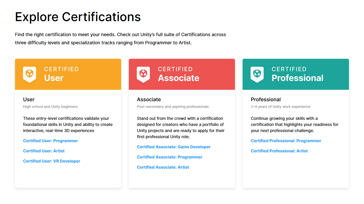
Сourse is partly built on how the division and certification is arranged for Unity Technologies company :

On the other hand, the structural division is combined at one stage in order to make it clear that such projects are almost always the result of coordinated work of different departments of the team.
Classes will be held offline. Groups will consist of 3-4 people. In total, ~9 people will work on the final project, divided into departments by specialization. Language of classes - English

Teacher
Aranovich Andrei Andreevich is a specialist in the field of XR development and creation of digital twins with more than 10 years of experience. Winner of the hackathon “Digital Breakthrough 2019” in the category “observation and analysis of human behavior using computer vision” - registered in the Guinness Book of Records as the largest in the world in terms of the number of participants.
Collaborates
Goethe Institute, Mestia Municipality, Library about Georgia

Learning Outcomes
We expect students to gain understanding, fluency in reasoning, and hands-on implementation skills of the following core systems concepts in extended reality field :
Modeling
- Low poly
- Hi poly
- UV
- Texturing
- Materials
Scanning
- Object Analysis
- Shooting
- Model processing
- Retopology
- Rebaking
Installation and use of XR SDK
- Oculus SDK API
- Gestures
Triggers and Colliders
- Collision Handling
- Running custom scripts
Teamwork
- Git and Github
- Youtrack
Briefs and Interactions with Clients
- How to interact with clients
- Healthy Boundaries
Tasks
At the first stage (the first 5 lectures), assignments should be completed individually, if any. Assignments will be checked partly during non-classroom hours and partly during lectures.
At the project stage, tasks will be solved in groups, but the task will be divided into different performers if possible. Review will take place at meetings
Course Logistics
Library about Georgia on Rustaveli gives the up-to-date office hours of all instructors for this class.
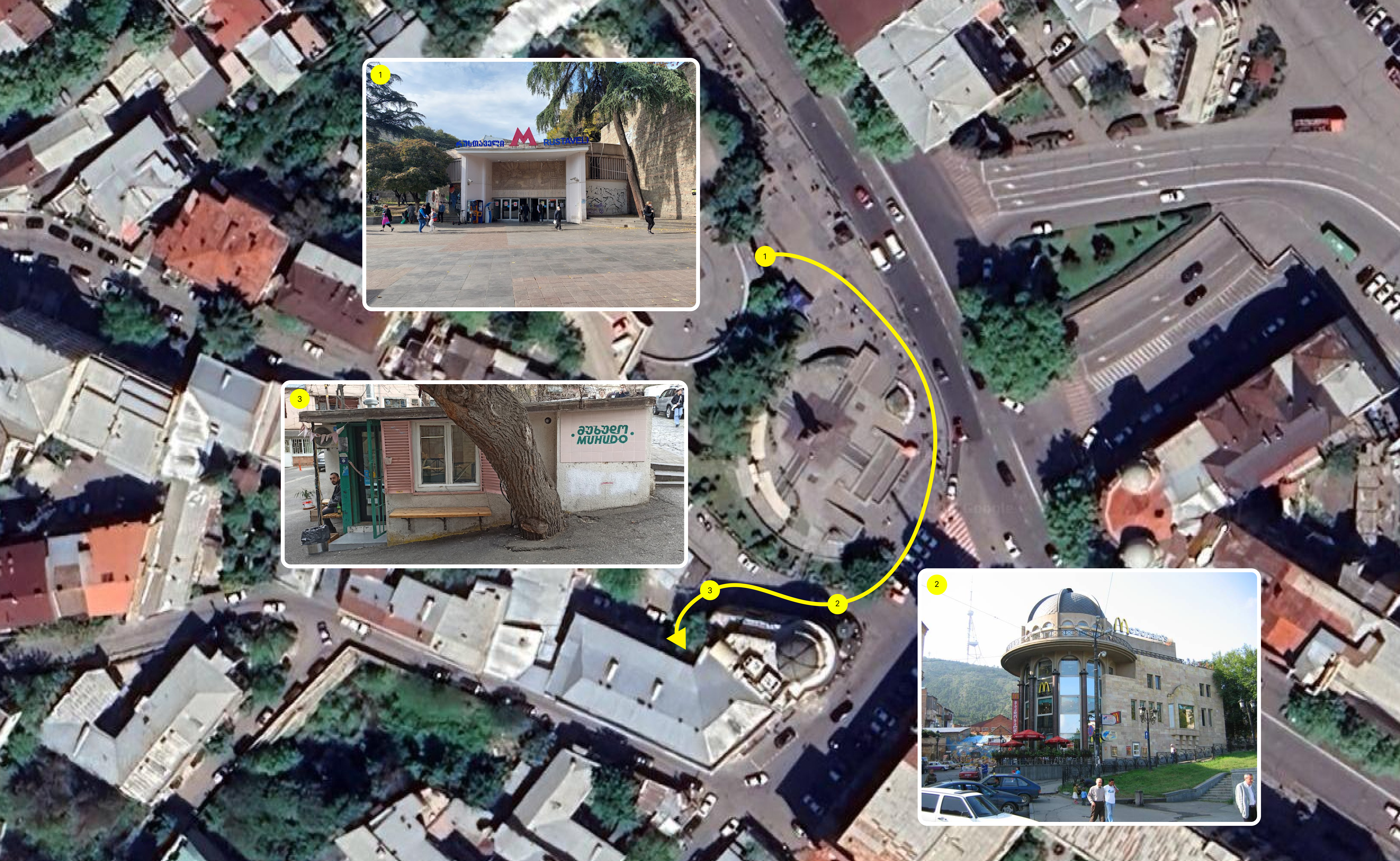
Address of classes : 3 Vasil Barnov St, Tbilisi, Rustaveli metro station

Schedule
Preliminary time information:
The start date of classes is April 15.
The time interval is from 12 pm to 20 pm.
The duration of the lesson for one group is 2-3 hours.
Event days - Monday, Tuesday, Thursday, Friday
The exact start date of classes and the time of classes will be specified in the near future, you will receive a notification. Information may be changed to make attending the course more convenient and accessible. By filling out the participation form, you indicate a time convenient for you that will be taken into account.

Checkpoints
During the course there will be 4 check points, these are:
01 - Introductory part
There we will analyze the specifics of your chosen direction within the XR industry. Let’s look at where and how, as well as master the basic software tools.
02 - Basic training
Over the course of a series of lessons, we will go through basic concepts and techniques that will help us in working on the project.
03 - Project part
Here we will meet with our Artists - “Clients” and learn how to create technical specifications for the project, after which we will apply previously learned techniques in teams to implement the project.
04 - Presentation and Exhibition
At this stage, we will organize an event in which we will demonstrate our project to the public.

Slides from Lectures and Recitations
Will be placed in the course area at Google drive soon after each lecture and recitation.
If you are authenticated at Youtrack, you can also access individual directories via links at relevant lesson task
These notes are for your personal use only. Please do not distribute them.
Exhibition
The completion of the project will be a presentation - an event at which we will demonstrate our work together with the artists participating in the project. The date of the exhibition, preparation for it and other stages will be discussed directly at the training courses.
Course Policies
Prerequisites
Since the course is introductory, the requirements are minimal, but nevertheless you will need basic computer skills and work in graphic and text editors, English language for. It is also advisable to have a laptop for work.
Recordings
A video recording is being made for internal purposes; you can find the recordings using the links to the general disk with lessons and links for tasks in Youtrack.
Filming by participants, as well as distribution of internal materials, is not permitted.
Course attendance policy.
It is allowed to miss 1-2 classes, which can be made up using records of missed classes and short consultations on an individual basis.
In case of systematic absence from classes (absence from more than 2 classes) There is no additional time provided to catch up on materials individually. Each such case will be dealt with on an individual basis, but additional class time or refunds will not be provided. A potential solution could be that there is a chance to move the student to the group for the next month if new enrollments are available.
Organization Style
To organize our work, we will use a project management system from JetBrains called Youtrack. This system is used in different companies, it also has alternatives like Jira and others. In addition to the convenience of organizing educational and project materials within the course, using this system, students will be able to get acquainted with what the organizational process looks like in large companies.
To exchange working materials, we will use Git and Github, which will be synchronized with Youtrack for version control within the project.
All materials on these technologies will be provided both during the course itself and outside of class for individual review.
layout: about
title: about
permalink: /
nav_order: 1
profile:
align: right
image: prof_pic.jpg
image_circular: true # crops the image to make it circular
Summer 2024, 10-17 June
Overview
XR-110 is a program that aims to provide the audience with a basic understanding of the concept of Spatial computing in an accessible language. Over the course of a week, participants will be involved in working on a prototype of a local map of the region in which they live. This will allow them to become familiar with cultural, economic and other aspects that relate directly to them through the prism of augmented reality technologies.
Since the topic of Spatial computing is quite complex and has a high entry threshold, in order not to scare off participants, the course is designed as an interactive step-by-step narrative - a set of quests. This was achieved through a number of decisions:
1) Several preliminary trips to the area were made (link 1,link 2) which allowed us to form a clear understanding of the audience and the tasks that can be set for it.
2) Based on the information collected during the field visits (a set of scans), a prototype of an interactive map application was created, which will be used for the visualization of the objectives and results of the course.
3) The format of the educational program consists of a set of missions set by the Youth Self-Government of the Municipality with a focus on gamification of the process.
The main topics to be covered in this course include:
-
Spatial computing
-
Modeling
-
Scanning
-
Working with a ready-made Spatial computing project
-
Teamwork

Course Instructor
Aranovich Andrei Andreevich is a specialist in the field of XR development and creation of digital twins with more than 10 years of experience. Winner of the hackathon “Digital Breakthrough 2019” in the category “observation and analysis of human behavior using computer vision” - registered in the Guinness Book of Records as the largest in the world in terms of the number of participants.

Collaborates
The course was created with the support of the Youth Self-Government of the Municipality of Mestia ( მესტიის მუნიციპალიტეტის ახალგაზრდული თვითმმართველობა )
The Tasks

The structure
The program will be divided into a number of stages:
-
1) Introduction to the concept of Spatial computing, setting tasks
-
2) Field visits, filming and processing of material
-
3) Integration of material into an existing prototype of the regional map application
-
4) Demonstration of the results of the work to a wide audience
1. Monument to Delica

Task:
Due to the exceptional technical characteristics and prevalence among the residents of the region, the task was set to create and place a monument to the Mitsubishi Delica on the map. This is the first task that will need to be completed on the course, within its framework, participants will receive basic experience working with objects, and the implementation of the possibility of working on cultural values.
Stages:
-
1) Find a Delica of a matte texture, which could be easily photographed
-
2) Scan the car,
-
3) Make retopology, and rebake
-
4) Make a design for the monument
-
5) Add rocks, place the Delica on them
-
6) Determine the place on the map where it will stand
-
7) Install the monument in the map
-
8) Build the application
Tags: #Basic, #Cultural
Equipment: Camera with a 25-35 mm lens
2. Wheat crop accounting

Task:
As part of the project on growing wheat in the region (link 1) it is necessary to visualize the areas involved in the program.
Stages:
-
1) Find out the boundaries of the areas where wheat is grown.
-
2) Go to the location and shoot the territory using a drone
-
3) Make retopology and rebaking
-
4) Determine the place on the map where it will stand
-
5) Install the object
-
6) Display infographics
-
7) Build the application
Tags: #Wide #Econimics
Technique:
Mavic drone

3. Basic survey of the territory ( Optional )
Task:
Reworking existing scans or surveying new areas. Provided that previous tasks were completed on time.